Subject: United States - Southwestern
Period: 1861-62 (circa)
Publication: Illustrated Family Atlas
Color: Hand Color
Size:
24.5 x 17 inches
62.2 x 43.2 cm
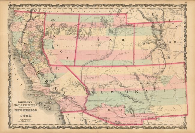
A very good example of this early map from Johnson's Southwest series, and one of the more uncommon configurations. The Confederate Territory of Arizona appears in the southern third of New Mexico Territory. Between August 1861 to July 1862, the Confederate General Baylor appointed himself the territorial governor and claimed all of New Mexico Territory south of the 34th Parallel for the Confederacy. The map names the "Gadsden Ten Million Purchase of Mexico" line between the U.S. and Mexico. Nevada Territory makes an early appearance with its proposed boundary wandering into the eastern state line of California along the Sierra Nevadas. California was already a state by this time, so this proposed boundary never really came to be official. Filled with historical notes and notations, one note near Quartzite, Arizona refers to the area as being "fertile and abundantly timbered and well watered," which it most certainly is not. The Emigrant Road, the Hastings Road, and the routes of numerous explorers and military expeditions are shown. The Gold Region of Colorado's South Park is prominent. Colorado had just been created as a territory in 1861 in the wake of the Pike's Peak gold rush of 1859. A superb map of the Southwest.
References: Wheat [TMW] #1027.
Condition: A
Original color on a sheet with some minor toning and a speck of foxing. A short separation in the lower margin is repaired on the verso with archival tape