Subject: Colonial Southeast
Period: 1775 (dated)
Publication: The American Atlas
Color: Hand Color
Size:
56.5 x 20.5 inches
143.5 x 52.1 cm
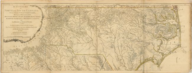
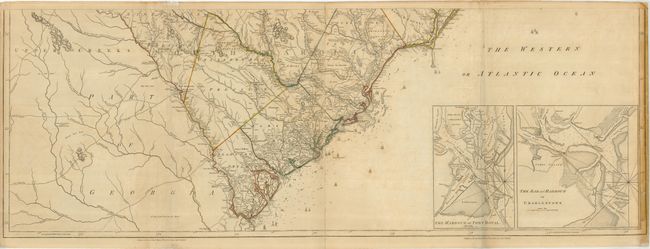
This rare map is the first edition of one of the foundation maps of the Carolinas. It was used by both American and British forces during the American Revolution and remained the major source of information on the region for the next fifty years. It is exceptionally detailed, with very meticulously noted roads, farms, forts, parishes, bridges, Indian paths, and boundaries. The coastlines include sailing directions, notations on currents, and soundings. Pamtiko (Pamlico) Sound is especially well charted from entrances at Cape Hatteras and the Roanoke Inlet. In North Carolina, Tryon County and Pelham County (later Sampson) appear for the first time. The topography west of the Catawba River is more detailed and accurate than on any previous map. In South Carolina, Mouzon's sophisticated and thorough cartography extends from the eastern settlements into the Appalachian Mountains and the Cherokee lands on the western frontier. The inset maps located on the lower sheet include The Harbour of Port Royal, and The Bar and Harbour of Charlestown. The map is printed on four sheets, joined to make two horizontal pairs (dimensions given for each) that if joined, would measure 41.5 x 56.5". First state, published by Sayer & Bennett.
References: Cumming (SE) #450; MapForum #4, Carolina #113; Shwartz & Ehrenberg pp. 186-87; Stevens & Tree #11a.
Condition: B+
Original outline color on sound sheets with some toning. Folds reinforced on the verso with archival tissue. The upper map has a repaired lower right corner with a small bit of neatline missing. The lower map is reinforced on the right edge, repairing some short tears that go just past the border. All in all, in very nice condition for a map of this size and rarity.