Subject: Alaska and Western Canada
Period: 1904 (dated)
Publication:
Color: Printed Color
Size:
19 x 12.6 inches
48.3 x 32 cm
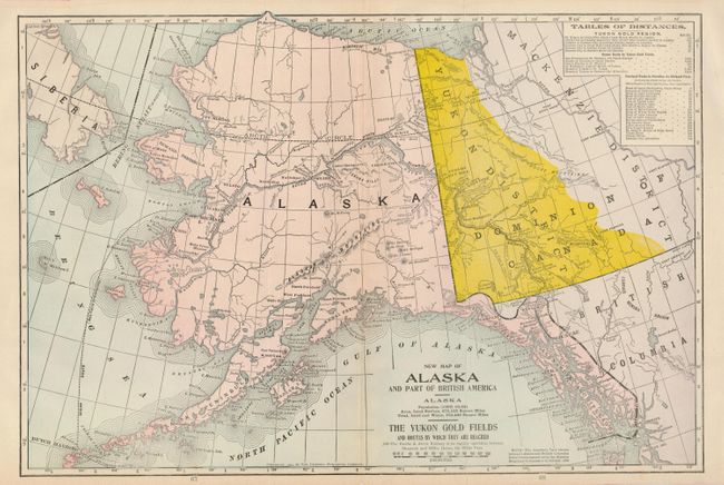
Attractive map of the region with special emphasis on the Yukon Gold Fields. The Yukon District indicated by bright yellow overprinting. The Ocean Route from Dutch Harbor to St. Michael Island is shown, and continues along the Yukon River crossing the entire state finally ending in Dawson City, in the heart of the Klondike Region. A table of distances and a note explaining the boundary between Alaska and British Columbia is according to the Alaska Boundary Commission in October, 1903. Trails, forts, towns, glaciers and the Teller Reindeer Station are also shown. Locates Ft. Morton, East Foreland (near today's ), Kaguyak, St. Paul, Barrow, Unalaklik, Kutlik, Circle City, Fort Yukon, and much more. The secondary title is "The Yukon Gold Fields and Routes by which they are reached. The Pacific & Arctic Railway is in regular operation between Skagway and White Horse, via White Pass."
References:
Condition: B+
Centerfold reinforced on verso with archival tape and just a trace of toning along centerfold.