Subject: Colonial United States & Canada, Great Lakes
Period: 1657/1900 (circa)
Publication:
Color: Black & White
Size:
15 x 20 inches
38.1 x 50.8 cm
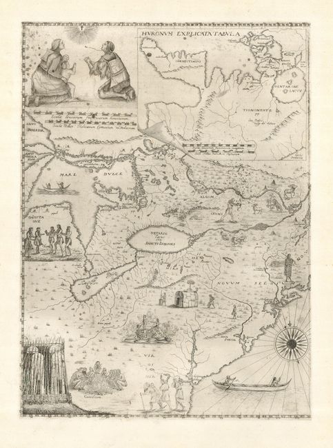
This incredible map of the Great Lakes region was prepared by a Jesuit priest who served in Quebec in the 1640s. Despite being captured and tortured by the Iroquois, he returned to Italy where he compiled this map. Drawn primarily from Jesuit sources, it is the most accurate depiction of the eastern Great lakes and Ottawa River region of the period. Lake Erie is placed at a higher latitude than on Sanson's map. Georgian Bay is described in great detail on the inset. The map is embellished with several depictions of the Indians including a converted family praying.
The map was originally issued on two-sheets in 1657; this being the left (western) sheet. The other side described the St. Lawrence River and contained a graphic view of the martyrdom of Fathers Jean de Brebeuf and Gabriel Lalemant at the hands of the Iroquois. This map's existence was unknown until an example was found in the D'Anville collection in Paris, and there are only two complete examples known. There are two states, the second having the engraver's imprint added to the inset map and a canoe in the Mare Dulce. The plate for the western sheet survived, although is now again lost. In the early part of the 20th century it was apparently used by a woman in Italy to restrike the map on old paper. There are a few examples of this state known to exist. This example is one of those later impressions.
References: Burden #323; Kershaw #147; Verner Stuart-Stubbs #6.
Condition: A
There are some spots in the image that appear to be residual printer's ink smudges, else clean and bright with wide margins.