Subject: World
Period: 1849 (dated)
Publication:
Color: Hand Color
Size:
30.3 x 19.3 inches
77 x 49 cm
In 1825 Haden Edwards received permission from the Mexican government to settle 800 families in East Texas. Edwards, a land speculator from Virginia, was known for his dishonest dealings with the settlers. After receiving many complaints the Mexican government revoked Edwards' grant in December 1826. Edwards and his brother, Benjamin, joined with local Indians (who felt Mexico had failed to deliver promised land) and settlers desiring to challenge Mexico's authority. They marched on the local capital of Nacogdoches on December 16, encouraged local residents to join them, and declared their independence from Mexico as the Republic of Fredonia.
In January, fighting erupted when settlers loyal to Mexico retaliated, further escalating with Mexican troops joined in fray. The Fredonians fled to Louisiana, and by the end of March 1827 the rebellion had been suppressed. The Republic of Fredonia, never recognized by any official entity, had lasted barely three months. The Mexican government then divided Edwards' grant and awarded it to other immigrants.
The Fredonia Rebellion was the third attempt at independence from Mexico. Texas Colonization became so popular with the Anglos that in 1830 Mexico reversed its position and barred further immigration. This action led the way to the "Battle of Nacogdoches," the opening skirmish in the Texas Revolution, which took place in August of 1832.
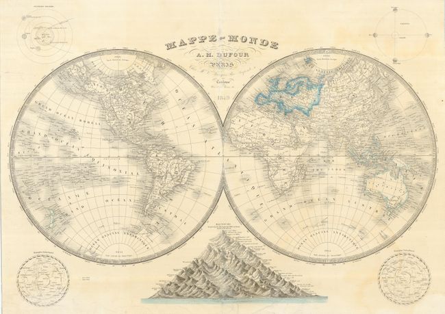
A large and very handsome copper engraved, double hemisphere world map with fine detail of the islands, major cities, watershed and topography. This map names Texas as Fredonia. The so-called Fredonia Rebellion was one of three conflicts leading to the independence of Texas. Fredonia was located in northeastern Texas, but is here depicted in the southern portion. Fredonia is rarely seen; in fact to our knowledge it is found on only a few published maps. This map shows only a hint of coastal information for Antarctica. In each corner is an example of a celestial chart, a diagram of the phases of the moon or a chart of the Solar System. A thematic chart at bottom displays all the mountains of the world as one large range with varying peaks to compare height.
References:
Condition: B
A little irregular toning and a few repaired short tears, with two just entering the image at top and bottom. There are some small scattered holes in the map, and some abrasion on the centerfold. Still an attractive map.