Subject: Exploration and Surveys
Period: 1832-36 (dated)
Publication:
Color: Black & White
Size:
5.5 x 9 inches
14 x 22.9 cm
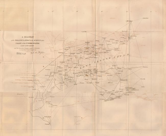
This important bound volume was owned by Thomas McDonnell of the Coast Survey and it contains a map signed by F.R. Hassler, the founder of the Coast Survey. The volume begins with Comparison of Weights and Measures of Length and Capacity…, which was printed by Duff Green in 1832. This first volume has 122 pages and bears the owner's signature of McDonnell, who served as an officer in the Coast Survey under F.R. Hassler, on the title page. Four plates of diagrams of the instruments used in the survey are bound in. The following section, Principal Documents Relating to the Survey of the Coast of the United States Since 1816 New York, William Van Norden, 1834, features the map A Diagram of the Triangulation for the Survey of the Coast of the United States made in 1817 and 1833, and Secondary Triangulation made in 1833 & 1834 in Connecticut and upon Long Island (18 x 13.8"), which is signed by Hassler. A small chart of handwritten measurements, probably done by Hassler himself has the title "Memorandum F. R. Hassler of Measurement on Long Island Base" was placed in between two pages. This chart is comprised of three columns - "Date 1834", "Number of Boxes", and "Number of Inclinations" and 11 rows of dates from August 2 to August 13. NOAA now calls this "The Great Fire Island Baseline", and at the time it was the longest and most accurate baseline ever measured. 180 pp., 3 pp. index, errata sheet.
The 156 page Second Volume of the Principal Documents Relating to the Survey of the Coast of the United States from October, 1834 to November, 1835, printed in New York by William Van Norden in 1835, along with the 123 pageDocuments Relating to the Construction of Standards of Weights and Measures for the Custom-Houses. William Van Norden, 1835 and Documents Relating to the Construction of Standards of Weights and Measures for the United States, from 1832 to 1835. New York, John Windt, 1836. 25 pp. Complete this exhaustive and very important report. 8vo. Original hardbound in marbled boards and half leather spine. Title in gilt on spine.
References: Guthorn p. 68.
Condition: B+
Map has tape repairs to tears and some offsetting. Contents generally good with some toning and scattered foxing. Some pages dog-eared. Covers detached and well worn. Book plate of Ralph Moore Berry pasted to inside front cover. Front endpapers loose, rear endpapers missing. Spine is attached but cracking. Binding still sound.