Subject: Africa
Period: 1849 (circa)
Publication: Atlas Universel Illustre
Color: Hand Color
Size:
17 x 11.3 inches
43.2 x 28.7 cm
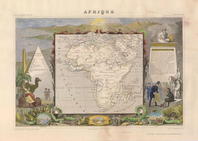
Victor Levasseur's "Atlas National Illustre" and "Atlas Universel Illustre" are among the last decorative atlases published. The maps are all lavishly illustrated with scenes of the countryside, products and activities indigenous to the region.
This decorative 19th century map of the continent is colored to show the colonial possessions and major tribal kingdoms. The interior is mostly void of detail, with the exception of the mythical Monts de la Lune, or Mountains of the Moon in the center of the continent. These legendary mountains were long thought to be the source for the Nile, dating back to Ptolemy. Stanley traced a fluvial connection from the Nile back to a mysterious snowy mountain range in Central Africa in 1888, dubbing the mountains Ruwenzori and proclaiming them the Nile source that Ptolemy described. The map is surrounded by steel-engraved scenes by Raimond Bonheur including the pyramids, wild animals, natives, the French army in Algeria and vignettes of Alexandria, Cairo, and Algiers.
References:
Condition: B
There are a few marginal stains and a repair on the Arabian Peninsula.