Subject: United States & Mexico
Period: 1858 (circa)
Publication:
Color: Hand Color
Size:
10 x 12 inches
25.4 x 30.5 cm
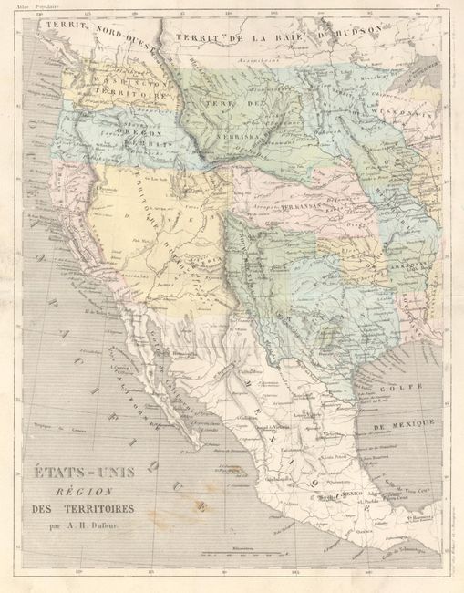
This is an interesting French map of the western territories depicting several incorrect boundaries, suggesting an older map than we have here. Nouveau Mexique is shown with the approximate boundaries of the old Spanish territory. The huge Utah Territory encompasses all of present day Nevada, Utah, Colorado, Arizona and part of New Mexico. Its boundary with California lies along the Sierra Nevada range. A small settlement of Arizona lies in the southern portion near the Mexican border. Nebraska Territory occupies the region between the Platte River and Canada, and from the Rocky Mountains to the Missouri River. Kansas Territory takes in present day Kansas, Nebraska and part of Colorado. The map shows the Gadsden Purchase boundary between the U.S. and Mexico. This map also notes a large German colony in the area of Fredericksburg, in central Texas. Fredericksburg was founded by German immigrants under the auspices of the Society for the Protection of German Immigrants in Texas. In 1846 John O. Meusebach led 120 fellow Germans into the area between the banks of the Llano and Colorado Rivers. Meusebach named the colony for Prince Frederick of Prussia. Beneath this colony is located a French colony. Both colonies are rarely seen on maps. An unusual map with some interesting territorial borders.
References:
Condition: B
Short fold split in margin has been closed on verso. The map has full, original margins and original hand coloring. There are some smudges in the Pacific.