Subject: United States & Mexico
Period: 1679 (dated)
Publication:
Color: Hand Color
Size:
21.5 x 12.3 inches
54.6 x 31.2 cm
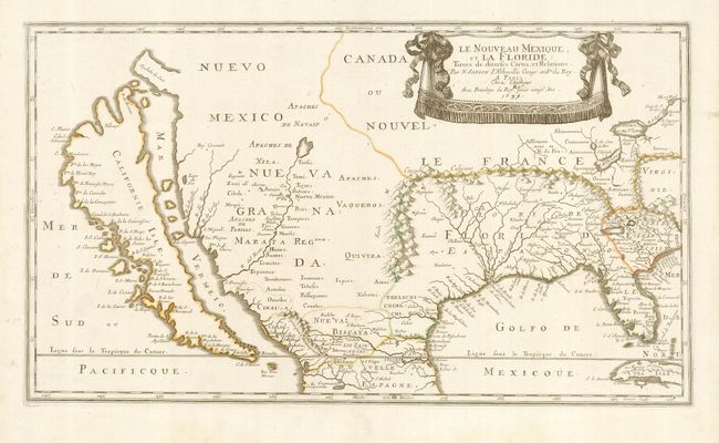
This is an extremely influential map; the first large-scale map to focus on the American Southwest and to focus in detail on a huge island of California. The information Sanson used to develop his concept of the island of California is drawn from information taken from a map by Luke Foxe, which showed the twin indentations at the top of the island, here named Talaago and R. de Estiete. The unusual peninsula of Agubela de Cato is of unknown origin, and in fact shows up on maps well into the 1700's. This map was produced just as French influence in Canada and the Ohio Valley was expanding. Sanson calls the coastal area between the Florida peninsula and Virginia Floride Francois, the first such designation. In Florida, he restored some French Huguenot settlements that had been eliminated by the Spanish in 1568, but, as Tooley notes, he also changed place names from French to Spanish. This is also the first application of the name of Lake Erie for a recognizable lake, here called Erie Lac. Sanson drew a ring of mountains, which, along with his compressing the land south of Lake Erie, enabled the French claims in the region to be greatly expanded against the competing Spanish and English claims. The Mississippi empties into a small sea called the Mar Pequeno, just above the mouth of the river, perhaps referring to Lake Pontchartrain. The Rio Grande, here called R. del Norte, travels from a large lake near Taos to the Mar Vermeio. This is McLaughlin's second edition, and Burden's fourth state with the alteration of the date to 1679.
References: Tooley (Amer) p. 115, #14; Burden #319; McLaughlin #17; Wheat (TMW) #50.
Condition: A+
Nice, clean example original outline color and a repaired fold separation in the lower, blank margin. The map has generous margins with an indistinct stain near Nueva Biscaya.