Subject: Kansas & Colorado
Period: 1862 (dated)
Publication:
Color: Hand Color
Size:
27.5 x 25.5 inches
69.9 x 64.8 cm
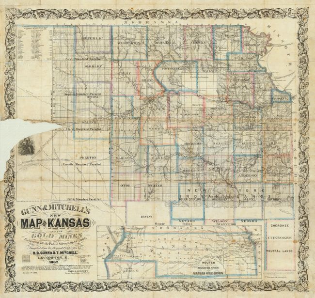
This scarce pocket map is the third edition of the map, first published in 1859. This edition provides additional survey progress and county development in Kansas. A long notation beneath the title by Ward B. Burnett, Surveyor General of Kansas and Nebraska, introduces the map with these words: "I take great pleasure in commending this Map compiled by O.B. Gunn & D.T. Mitchell to the Public use as an accurate delineation of the Surveyed portions of the Territory of Kansas to this date. I have reason to believe also that the Towns and Roads are correctly located thereon; in as much as the Town sites where obtained by him from the entries at the various land Offices and the Roads from the proper Authorities."
The pocket map was originally published with its 64-page guide the "New Map and Hand-Book of Kansas & The Gold Mines …," (not present in this lot). The guide was important for the part it played as a guide to the Pike's Peak Gold Rush. The map contains the large inset: "Routes from the Missouri River to the Kansas Gold Mines". The inset (5" x 15") locates the Gold Regions and shows two suggested routes to them. The inset also locates the Santa Fe Trail, here called the Great Santa Fe Road. The large map covers the settled portion of Kansas, that is the northeast quarter of today's Kansas. It details all of the state with all counties named and shows townships and survey progress. The map is embellished with wide, decorative border, vignette of a Native American warrior, and fancy titling. A table at upper left lists the population for each county according to the 1860 census.
Printed in Pittsburgh by Wm. Schuchman. The first edition was compiled by Gunn; Mitchell was added in 1861 and helped compile all subsequent editions (1862, 64, 65, 66, and 67). Holes lists the 1859 edition as very rare while this edition is noted as scarce. A most desirable map that will be a real star with a little professional attention.
References: Rumsey #3632; cf Wheat (TMW) 976 and Streeter 2017; Wagner-Camp #327:2.
Condition: C
Printed on thin banknote paper. Original hand coloring and nice impression. Issued folding, now backed on thin Japanese tissue. A couple of small holes with little loss in inset map. The main map has a portion of paper missing at left center, just affecting top of one vignette and just entering Saline county.