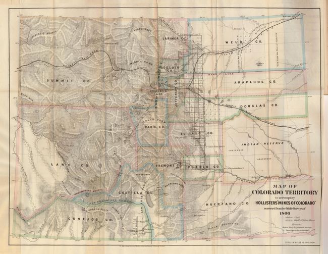
Subject: Colorado
Period: 1867 (published)
Publication: The Mines of Colorado
Color: Hand Color
Size:
21 x 16 inches
53.3 x 40.6 cm
This scarce map of Colorado shows great detail throughout. The map lists sixteen counties and a large Indian Reserve. The reserve is divided into Cheyenne and Arapahoe tribes. There is extensive watershed information and mountains are shown in hachure. Locates all mining communities, forts, railroads, and more. This is a handsome map in original outline color. The map is still bound in the rare enlarged edition (the first to contain the map) of this important book on Colorado: "The Mines of Colorado." It provides a view of the geography, geology, climate, and agriculture etc. Extensive information on over 165 mining enterprises. Hardbound in maroon cloth, gilt titling on spine, 450 pp. with 11 additional pages of advertising at back. A scarce issue, as these books are rarely found with the map intact.
References:
Condition: A
The folding map is near fine less a 3" tear from the binding trim that just touches the edge of Weld County. The book cover is a little rubbed with some chipping on spine. The contents are near fine less the first few pages with a tiny stain at upper corner with some paper loss, well away from printing.