Subject: Alaska, Gold Mining
Period: 1880-98 (dated)
Publication:
Color: Printed Color
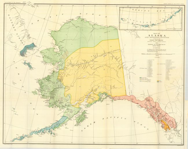
A fine historical pair of maps of Alaska covering early surveying and census data with the latter extending to include the great Alaska Gold Rush and the Klondike Gold Fields. The first map is dated 1880 and was published by the Dept. of Interior for the Tenth Census. It is a fine and detailed map of Alaska with numerous place names on the Kenai Peninsula and along the coast. It contains an inset detailing the Bering Sea and Aleutian Islands. The map features dramatic and quite early topography with notations crediting Russian, French and English charts. (30.3 x 24.5")
The second map was published by the General Land Office in 1898. It is a large and colorful map of Alaska Territory published at the beginning of the Yukon Gold Rush. It features a large inset of the gold region titled From Juneau to Forty-Mile Creek. A legend identifies regions with reported gold discoveries (highlighted in yellow), deposits of silver, copper and coal, church locations, and routes of the railroads, both existing and proposed. Another inset details the Aleutian Islands. Large text box provides distances from the U.S. to locations throughout Alaska, e.g. San Francisco to Chilkoot Pass - 1186 miles. Steam ship routes are detailed from San Francisco plus internal mail routes are shown in overprinted colors. Compiled and drawn by M. Herdges under the direction of Harry King, Chief of Drafting Division. A remarkable record of the great Alaskan Gold Rush. (32.3 x 25")
References:
Condition: A
Both folding, as issued.