Catalog Archive
Auction 119, Lot 193

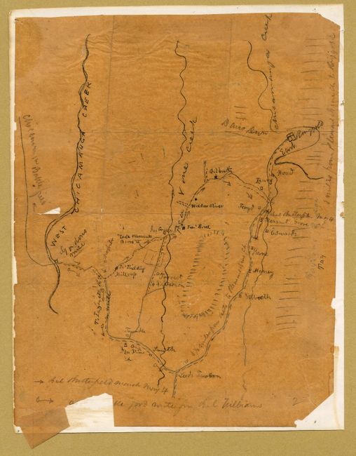
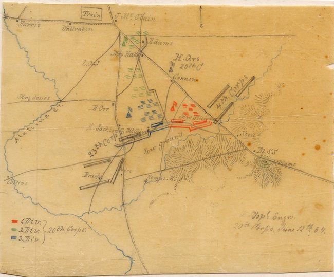
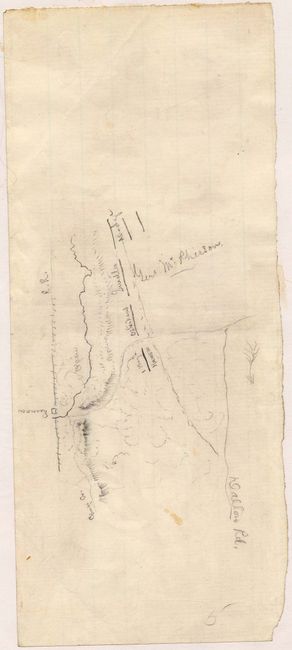
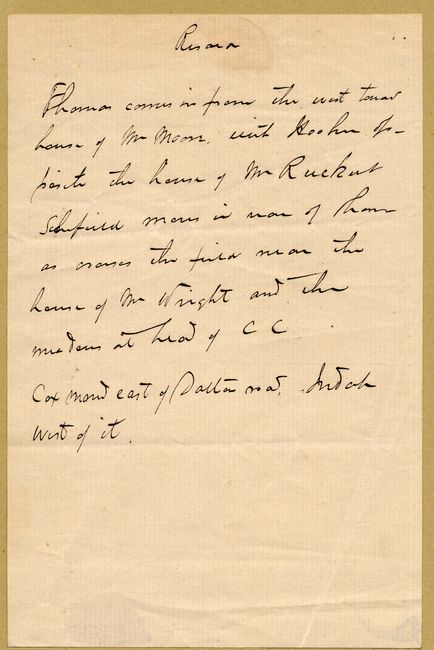
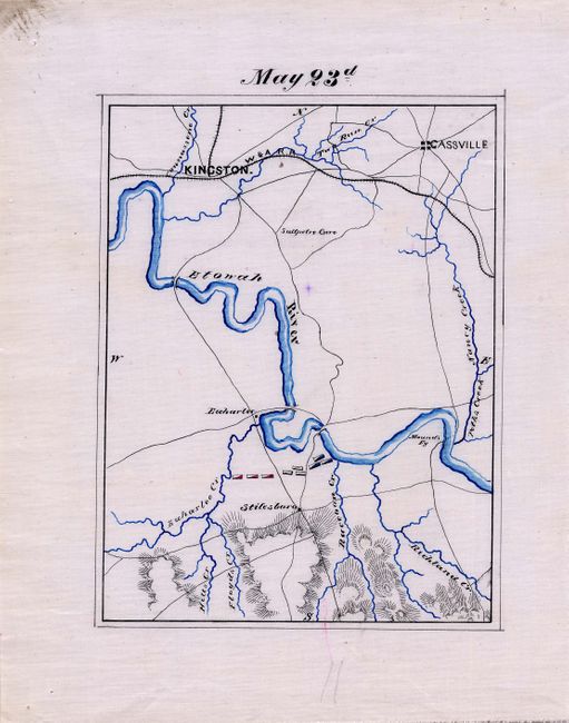
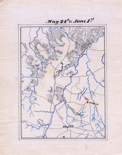
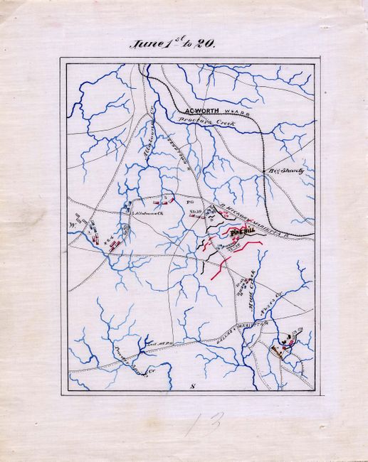
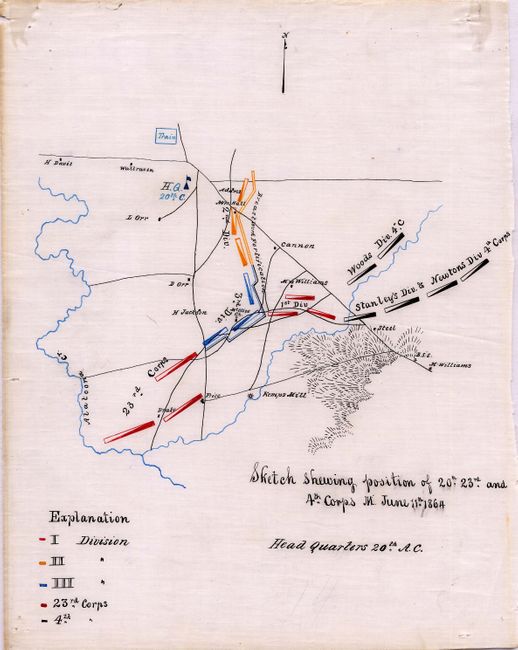
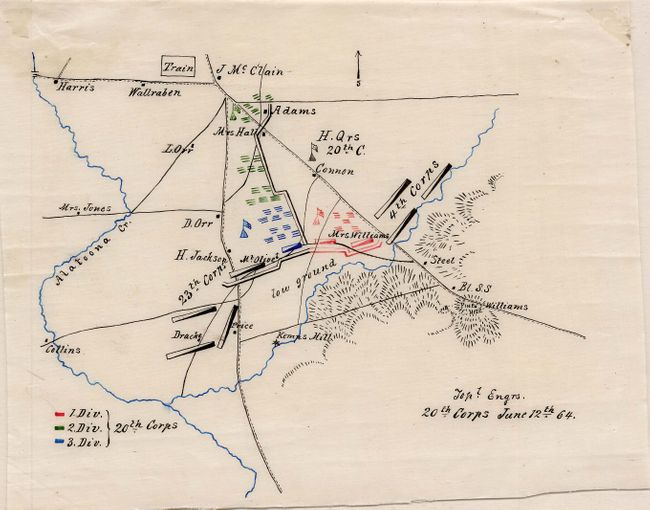
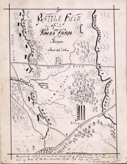
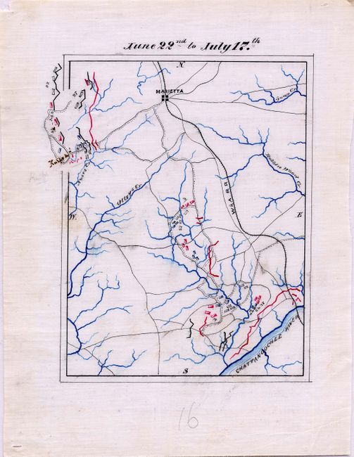
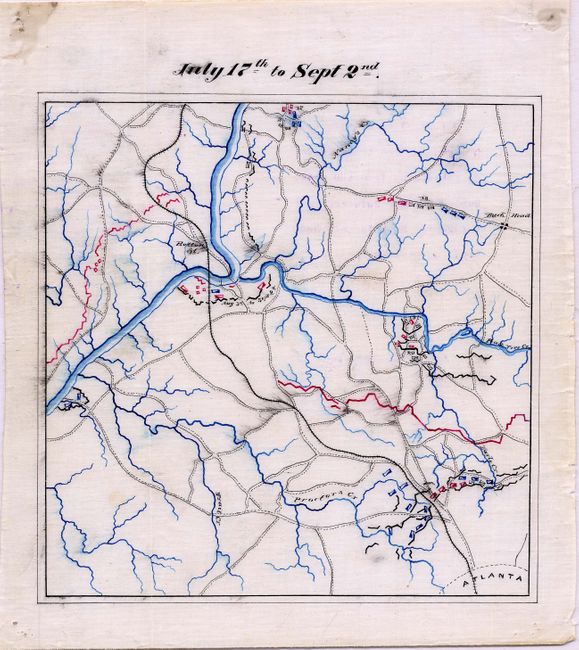
"[Collection of 22 Civil War Maps]", U.S. War Department

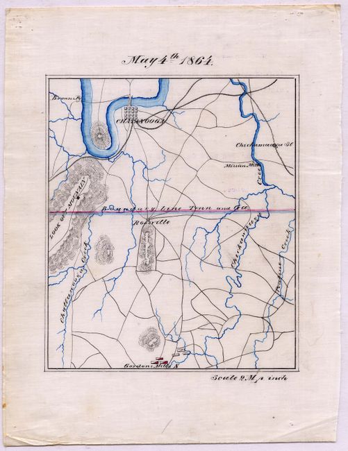
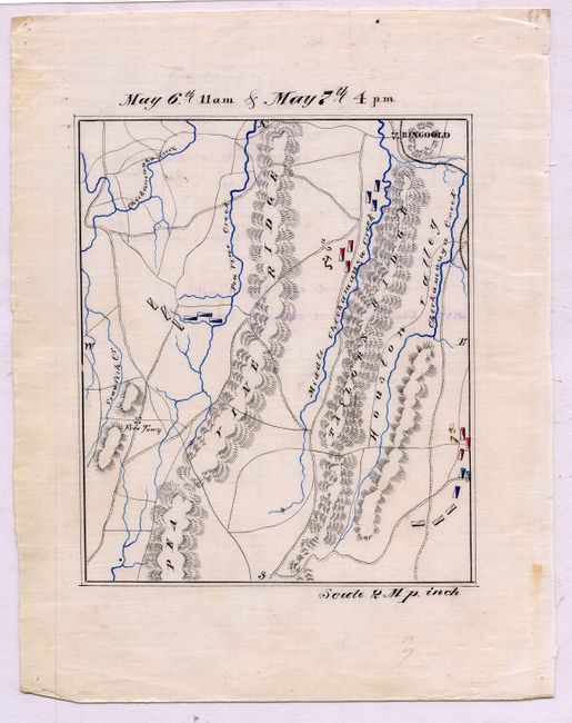
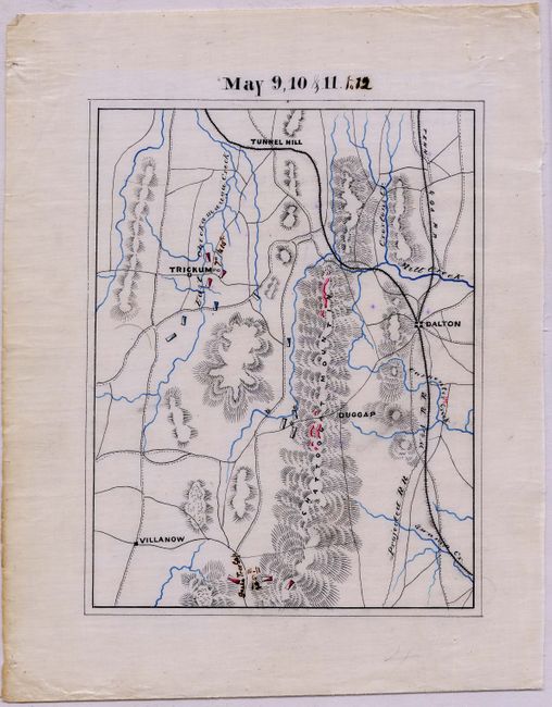
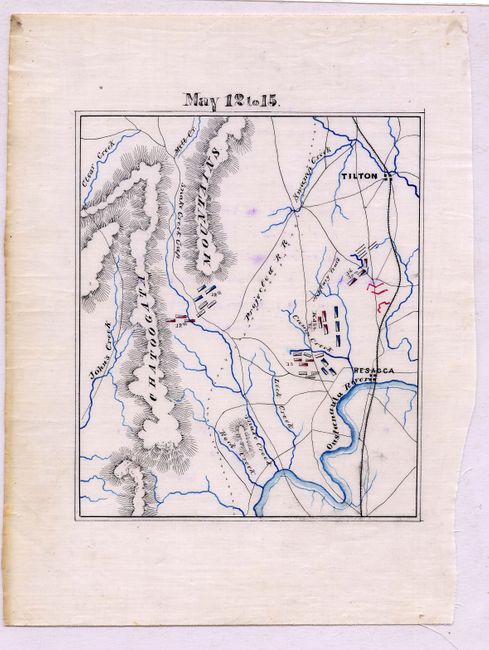
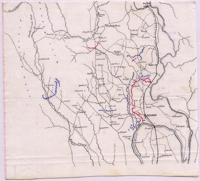
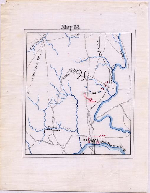
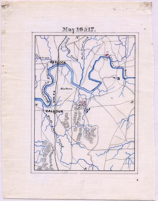
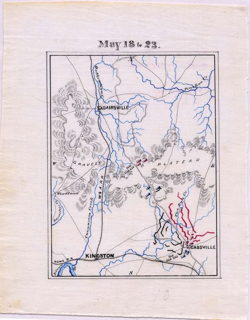
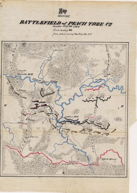
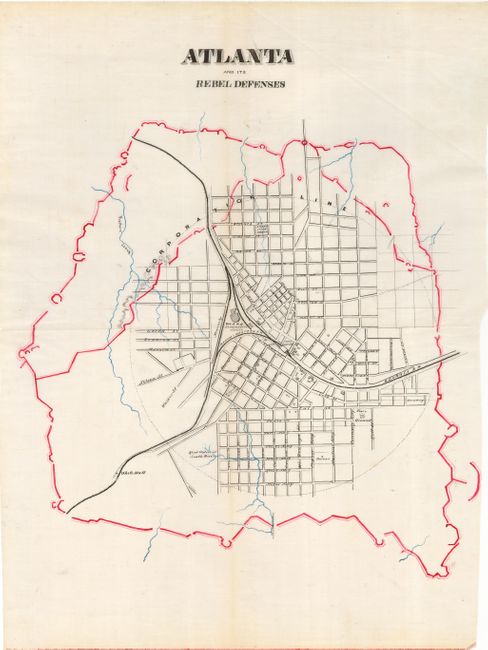
Subject: Southern United States - Civil War

Period: 1864 (dated)

Publication:

Color: Black & White

Size:
7.5 x 9.6 inches
19.1 x 24.4 cm
Download High Resolution Image
(or just click on image to launch the Zoom viewer)


Collection of 21 manuscript Civil War maps and one letter. This unique collection of maps relates to the campaigns of General Sherman and, specifically General Williams during 1864 and 1865. The collection includes three field drawn battle maps on paper, a field prepared note or letter related to Resaca, and eighteen manuscript scribed battle maps, likely created as master maps for photographic reproduction in the monumental Atlas to Accompany the Official Records of the Union and Confederate Armies. The provenance of the collection is uncertain, but the owner's father was friends with and lived next to Milo Quaife. Mr. Quaife edited "From the Cannon's Mouth" a published collection of letters from Brigadier General Williams to his daughter during the war.

The first three maps are drawn on thin paper and appear to be contemporaneously field sketched during the campaign of General Williams. These maps include:

1) An Untitled map describing the Opening of the Atlanta Campaign, May 1864 , 7.5 x 9.6". This map represents the early movements of General Williams' Division on or about May 4, 1864. Drawn in ink and pencil it appears to be an early reconnaissance map and is noted "probable good route for Gen. Williams," and "Genl Butterfield March May 4." The drawing is filled with information and details including property owner names, physical features, distance to places off the map, etc. A remarkable 'work in progress' with a good deal added in pencil in the same hand. West Chicamauga, Pea Vine and Chicamanga Creeks are named. On thin, fragile paper. 2) "Topl. Engrs. 20th Corps June 12th 1864", 7.7 x 6". This field drawn manuscript in pencil and colored pencils shows the positions of the 20th Corps 1st, 2nd and 3rd Divisions, the 23rd Corps, and the 4th Corps. The drawing also locates the "H. Qrs 20th C." as well as property owners, roads, the Alatoona Creek and other topographical information. A notation reads "Williams" near Pine Hill and another says "Train" in a box at the top. On thin, fragile paper. 3) An untitled manuscript map, May 14, 1864, 7.7 x 3.2". This small and delicately drawn field map relates to the Battle of Resaca. Executed in pencil on a small piece of lined stationary paper, the drawing locates Resaca on the railroad, Camp Cr., Dalton Rd. and the position of four troop positions (1st Brig. Harrow, and three others this cataloger cannot read). There is also a note on Genl McPherson's position. A large creek is shown flowing from the south to Resaca, but it is not labeled Snake Creek. 4) "Resaca" is a Field Note or letter, unsigned, 5.3 x 8". The note begins "Thomas comes in from the west toward house of Mr. Moor with Hooker opposite the house of Mr. Ruckert Schofield moves in rear of Thomas as crosses the field near the house of Mr. Wright and the meadow at head of CC. Cox ____ east of Dalton road Judah west of it." It is unclear if this is a battle plan by, perhaps Gen. Williams, or simply a cartographer's note.

The following 18 manuscript maps are scribed and drawn on oiled cloth, except one that is on paper. They are arranged chronologically. Those that can be identified as being from the work of cartographer Lucius Thaddeus Stanley of the 12th and the 20th Corps are identified as such. The first three maps may also be the work of Stanley; although that is uncertain, but the style is similar. See "Maps and Mapmakers of the Civil War" for some illustrated maps by Stanley in the Gilder Lehrman Collection that is currently on deposit at the Pierpont Morgan Library in New York.

5) "May 4th 1864," 5.7 x 6.7". Centered on Rossville with Chattanooga above and Gordon's Mill at bottom. After Stanley. 6) "May 6th 11 a.m. & May 7th 4 p.m.," 5.7 x 6.7". Ringoold at upper right. Locates Pea Vine, Crawfish, Middle Chickamouga, and Chickamouga Creeks. After Stanley. 7) "May 9,10 & 11 to 12," 5.7 x 7.3". Locates the towns of Trickum, Duggap, Dalton, and Villanow. Names Tunnel Hill Mill, Carpenter and Croxton's Creeks. Shows the Tenn. & GA, W & A Railroads plus a projected railroad extending south from the W&Q Railroad near Carpenter Creek. After Stanley. 8) "May 12 to 15," 5.6 x 6.5". The towns of "Resacca" and Tilton are located as is the Oustanaula River, and Clear, Mill, Snake, Rock, Lick, and John's Creeks. Names the Snake Creek Gap. After Stanley. 9) Untitled Battle of Resaca, May 14th, 10.7 x 9.5". Shows a detailed view of the vicinity around Resaca and Tilton with individual houses identified with owners' names. Identifies Snake Creek Gap and the "More" home mentioned in the letter noted above. 10) "May 15," 5.7 x 6.6". A very detailed map related to the Battle of Resacca. Very close detail around Resacca, the map extends only to show a small portion of Swamp Creek to the northwest. Locates the Projected railroad. After Stanley. 11) "May 16 & 17.," 5.25 x 7". Resacca is at upper left with Calhoun below. Troop positions are indicated for the two days. After Stanley. 12) "May 18 to 23," 5.2 x 6.8". Details troop positions and movements between Adairsville, Kinston and Cassville. Locates Pine Loo, Oothecloga, Barnsleys, Two Run, and Connasone Creeks and a small portion of the Etowa River. After Stanley. 13) "May 23d," 5.3 x 6.9". Locates Kingston, Cassville, the villages of Euharlee, Saltpetre Care, and Stilesboro, and the Mounds Foundry. Names Euharlee, Hills, Floyds, Raccoon, Poths, Nancy, Richland, and Two Run Creeks. After Stanley. 14) "May 24th to June 1st," 5.3 x 6.9". The town of Dallas is at bottom center with the terrain and watershed detailed including Floyds, Little Pumpkin, and Pumpkin Vine Creeks named. After Stanley. 15) "June 1st to 20," 5.3 x 6.8". This map is roughly centered on Pine Hill and names Big Shanty, Allatoona Church, Lost Mr. P.O. and another unnamed post offices. Names the W&A, Marietta, and Dallas & Marietta Railroads. Shows many creeks and rivers, but only the Allatoona, Powder Springs, Mud, Moses, and Proctors Creeks are named. After Stanley. 16) "Sketch shewing position of the 20th, 23rd, and 4th Corps M. June 11th 1864 Head Quarters 20th A.C.," 7.7 x 9.8". This is a very similar to #2 above with additions to the legend and different troop positions. 17) "Topl. Engrs. June 12th 1864," 8.8 x 7". This is a scribed copy of #2 above. 18) "Battlefield of Kolbs Farm. Georgia June 22nd 1864," 5 x 6.9", drawn on paper rather than oiled cloth. Bisected by the Marietta Road. Also shows the Powder Springs & Marietta Road, Little Neuse Creek, and Kolb farm. Details the long Confederate Line of Fortifications. 19) "June 22nd to July 17th," 5.6 x 6.8". Marietta is at upper center with the Chattahoochee River at lower right. Notation at top appears to locate the Kolbs house. Shows the W&A Railroad and other wagon roads leading to Marietta. Names Soap, Moses, Olleys, and Robbers Wood Creeks. After Stanley. 20) "July 17th to Sept 2nd," 7.5 x 7.5". The map has smear marks from some of the black lines, probably leading to it being abandoned. All roads, railroads and watershed complete with Atlanta named at lower right. Also names Proctor's, Peach Tree, Harley, Nancy, and Trail Creeks, Buck Head, and some troop positions. After Stanley. 21) "Map showing Battlefield of Peach Tree Cr Fought July 20, 1864. Scale 4 inch p Mile from actual survey Top Eng 20 A.C.," 9.6 x 10.2". Beautiful map centered on Colliers Mill. Locates the Union and Rebel breastworks with part of the Rebel fortifications labeled "White House." Names the Mt. Zion church and a few individual homes with the owners' names of Emery, Collier, and H. Emery. After Stanley. 22) "Atlanta and its Rebel Defenses," 13.5 x 18.1". This plan of Atlanta is a fabulous and large manuscript map on cheese cloth. The major streets are named, the Fair Ground, Cemetery, the Locomotive Hose of the W&A Railroad, the Atlanta Steam Tannery, White Hall and the headwaters of South River are indicated. The tracks for the Georgia, and the Macon & Western Railroads are shown. After Stanley.

References:

Condition: A

First two a little toned and fragile on thin paper. The others generally vary very good to fine.

Estimate: $25,000 - $35,000

Unsold

Closed on 5/9/2007

Archived