Subject: United States, Texas
Period: 1848 (published)
Publication: HR Doc. #1, 30th Congress, 2nd Session
Color: Hand Color
Size:
21.5 x 13.8 inches
54.6 x 35.1 cm
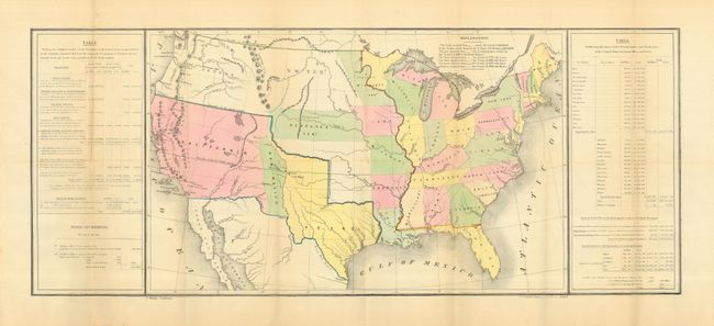
Important and uncommon map showing the new state of Texas with its northern boundary extending to 42° N. latitude in the 'stovepipe' configuration of the state at its largest extent. A large California Territory extends nearly to Texas with a small New Mexico sandwiched in between. Sutter's Fort is shown incorrectly on the Plumas River. Interesting versions of treaty boundaries are drawn and a table of explanations provides treaty dates. This is sometimes referred to as the Tables Map because a table on each side of the map offers selected statistical information including details on the "Three Divisions" of Texas. The right side table divides states and territories into Free States and Slave States. Wheat notes the map was probably prepared for the General Land Office to show Guadeloupe-Hidalgo treaty lines. Printed by Duval in Philadelphia and drawn by E. Gilman.
References: Koepp CIS 537; Wheat (TMW) 561; Streeter Sale 3876
Condition: A
Folding, as issued. One or two very small spots in map image. Overall a very clean and bright example.