Subject: Western North America - Pacific Northwest
Period: 1772 (published)
Publication: Diderot's Encyclopedie (Supplement)
Color: Black & White
Size:
14.75 x 11.25 inches
37.5 x 28.6 cm
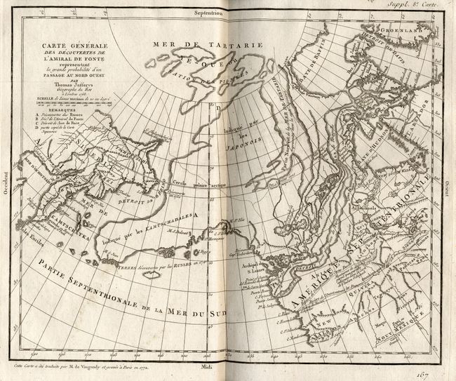
When Charles Joseph Panckoucke took over publication of Diderot's Encyclopedie in 1768, he promised to correct the cursory treatment of geography for which the first seventeen volumes had been criticized, with emphasis on the discoveries of the last 25 years. He employed Samuel Engel, a Swiss geographer, to write a series of articles about the northern regions and Didier Robert de Vaugondy to prepare ten maps to illustrate them. Engel rejected the De la Fonte Northwest Passage discoveries and believed the most sensible route from the Atlantic to the Pacific was along the north coast of Siberia. These maps illustrate the discoveries and various cartographic theories concerning the Pacific Northwest, East Asia and the North Pacific Ocean and include some of the most interesting comparative cartography of the eighteenth century
This is probably the most extravagant of all the Northwest Passage maps. Thomas Jefferys was an ardent believer in the northern route to Asia and prepared this map to show the passage, and especially its entrance on the West Coast, as described by Juan de Fuca in 1592, and in the fictitious story of Bartholomew de Font's discoveries in 1640. Alaska is shown in an early form based on the map of Mueller. This map is from a set of maps prepared by Didier Robert de Vaugondy to illustrate the articles written by Samuel Engel concerning the recent discoveries and cartographic theories in the northern regions.
References: Pedley #455; Hayes #34.
Condition: A+