Antique Maps, Charts, Atlases and Globes for Sale at Auction

Old World Auctions - Antique Map Specialists


Antique Map Auction Sale No. 115 - closed 6/21/2006

Featuring 830 lots of rare antique maps, charts, pocket maps, globes and atlases
Prices Realized       Table of Contents       Search Auction


Lot #299: 
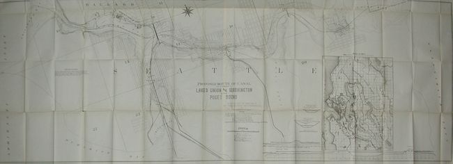
"Proposed Route & Canal to Connect Lakes Union and Washington with Puget Sound, Surveyed under the Direction of Capt. Thomas Symons" U.S. Corps of Engineers

Antique map chart Proposed Route  Canal to Connect Lakes Union and Was
Click to see full size image(s)

Estimate:
$150.00 - $200.00
Sold for: $210.00

Lot 299
By: U.S. Corps of Engineers
Subject: Washington
Date: 1891

Publication:

Condition: A
See Condition Guidelines

Color: uncolored

Size: 70.8 x 25.8 inches
179.9 x 65.6 cm

A remarkable document that details the plans to connect Lake Washington via Lake Union to Puget Sound. This is an enormous lithographed map on two joined sheets, as issued. The main map shows the planed canal and locks between Union Bay, Lake Union, Salmon Bay, and on to Puget Sound at Shilshole Bay. Of historical interest is the second proposed canal from Salmon Bay to Smith's Cove on the sound; a route that was not built. With a large inset map of the Seattle metropolitan area. Profiles along bottom detail the elevation changes and required locks for the Smith's Cove to Salmon Bay canal, and the Shilshole Bay to Lake Washington canal. The canal was first suggested by Thomas Mercer in 1854. After the failure of several private efforts, in 1917 the U.S. Army Corps of Engineers under Gen. Hiram M. Chittenden began construction. To read more on the history and construction of the canal click here.

Folding, as issued. One fold with several fold intersection splits and trace of toning, still very good for a map of this size.

See on Map Price Guide | See similar on Map Price Guide
Search this archived auction | Antique Map Price Guide