Subject: Holy Land
Period: 1611 (published)
Publication: Liber Secretorum Fidelium Crucis
Color: Black & White
Size:
14.8 x 6.2 inches
37.6 x 15.7 cm
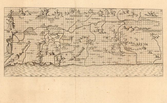
This scarce map is a printed version of Petrus Vesconte's landmark manuscript map - the basis for all early cartography of Palestine. The Holy Land is oriented with east at the top, and the coastline, mountains, rivers and places are all fairly accurate. It is remarkable for its network of lines, which provide a kind of latitude and longitude scheme. Old Testament iconography is emphasized and includes the locations of the Twelve Tribes, a depiction of the tomb of Job, and inscriptions marking where Lot's wife was turned into a pillar of salt. Crusader forts are located along the coastline.
Marino Sanudo was a Venetian statesman and geographer in the 14th century. He is best known for his life-long attempts to revive the Crusades. His great work the Secreta (or Liber Secretorum Fidelium Crucis), which was written in manuscript and presented to popes and kings in an attempt to persuade them to launch another series of crusades. Through its accompanying maps and plans, which were the work of the great sea-chart maker Petrus Vesconte, it occupies an important place in the development of cartography. The Secreta was only printed once and published with Bongars Gesta Dei per Francos, by Wechelius in 1611.
References: Laor #783; Mickwitz & Miekkavaara (Nordenskiold III) #346-II-2; cf. Nebenzahl (HL) plt. 15.
Condition: A
Overall very good with wide margins and a sharp impression, with a bit of faint foxing.